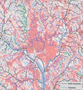
Before there was a capital city on the Potomac or a port in Baltimore; before the Beltways, the suburbs, the strip malls and subdivisions, there were streams – a lot of them, apparently. Recently, scientists from the University of Maryland’s Center for Environmental Science developed high resolution maps that identify headwater channels throughout the Potomac River watershed that were overlooked previously, or are now buried under modern development. They estimate that previous maps of the Potomac and surrounding watersheds underrepresent natural stream density by up to 250 percent.

Credit: University of Maryland Center for Environmental Science/Andrew Elmore
Most watershed maps in the U.S. are based on the National Hydrology Dataset, information first developed by the U.S. Geological Survey (USGS) in the middle of the 20th century. But the dataset isn’t comprehensive: it doesn’t include streams that were covered up by roads or other uses before then, and it omits many small streams – often the headwaters.
The University of Maryland scientists developed their map in two phases. First, they followed a sample of stream channels up to their headwaters in forested regions of each different type of landscape west of the Chesapeake Bay, including the coastal plain, the Piedmont, the Blue Ridge, the ridge and valley region, and the Appalachian Mountains, and recorded the location of the channel heads. Then, they used detailed USGS topographic data of the entire region to model the likelihood of other locations – based on slope and other topographical features—to contain headwaters and stream channels. They compared their simulated streams against the sample streams they actually documented, to verify the validity of their model. The result is a high resolution map of the Potomac River watershed and five surrounding watersheds in Maryland riddled with a dense network of waterways.
Not all of those waterways exist today. Small streams often are the first to go when people settle an area because they’re easily filled in for roads or other uses. As urbanization increases, streams get diverted into storm drains and landscape features – including those that alter stream direction – change. But, according to Dr. Andrew Elmore who led the research project, understanding likely stream locations is essential for land use planning. Maps that identify these locations can help planners and developers flag areas that might need riparian buffers, additional stormwater management, or other efforts to protect water quality and aquatic ecosystems. Areas with very dense stream networks might be less appropriate for development.
Elmore’s team already has shared its mapping data with Maryland’s Department of Natural Resources and local wetland and watershed groups involved in land use decisions. Anyone interested can view the maps online at http://streammapper.al.umces.edu/. Those who need the more detailed background GIS data used to produce the maps should contact Dr. Elmore directly at aelmore@al.umces.edu.


2 thoughts on “Who Knew? Scientists discover hidden streams in Potomac River watershed”